|
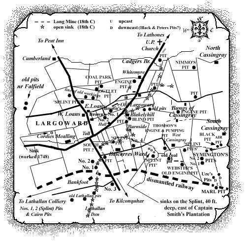
Examination of a copy of a plan/map adorned with
superimposed handwritten-text, lines, symbols and drawing
reveals that the Largoward coalfield was rich in many
unnamed old shafts and shallow workings, or
sinks, to the various seams such as Splint, Thick,
Marl, Black, Whitemire and Parrot coals. The plan is
quite likely to be the only evidence that these
coal-works once existed. Nevertheless, they too deserve
to be recognised in a comprehensive catalogue of the pits
and mines of Fife.
However small, these old coal-works would have posed
considerable dangers to the men and women who wrought
long hours in them!
Click on Map to Zoom In
| Ample evidence of the Largoward Splint Coal being worked
from numerous sinks in the fields near West Loans
and on the opposite side of the road close to Ash Grove
Villa, south of East Loans. |
| The 'Splint Pit' immediately north of Balcarres
Ward met the Splint seam at 40 fathoms. |
| Several of the sinks to the Splint Coal, at Captain Smith's Plantation to the east of Balcarres Ward, were
recorded as being 40 ft. deep. |
| The 'Splint Pit' to the south-west of Captain
Smith's Plantation was sunk to a depth of 168 ft. or 56
fathoms. |
| The 'Splint Pit' to the north of East Loans,
close to the line of old workings pushing eastwards towards old
Largoward, met the Splint Coal at 40 fathoms. The line
of old workings was almost paralleled some 60 yds. to the
south by the crop of the Top Marle Coal (also referred to as
the No. 2 Marle Coal), this crop continuing to run eastwards,
keeping north of Blakelyhill. |
| The Splint Coal has also been worked from two old
pits to the north-east of Blakelyhill where crops of the
Thick, Marl and Splint Coals were encountered. No details of
seam thickness or shaft depths are available. |
| See Largoward
Colliery entry - East Fife Index. |
|