Owners: J. Thomas
James Martin, Cults, Ladybank
Cults Lime, Springfield, Cupar
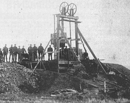
The Rameldry coalfield was an isolated tract of coal-bearing strata lying a mile to the south-east of the village of Kettle, where it was brought down by a large fault. Mining was known to be taking place at Rameldrie in 1850 but it is quite likely to have been a local activity in an earlier period.
 |
 |
|
Although January 2002 research has clarified more
shafts and mines in the Rameldry coalfield, the common
practice of numbering early shafts, then renumbering
later shafts, is making accurate identification of some
individual pits impossible at this stage.
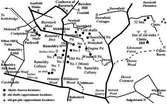
We have references to an Old No. 1 (also known as Moss Pit), Old No. 2, and further Rameldry Nos. 1, 2, 3, 4 pits from abandonment plans. An early Rameldry record encountered dates from 1873. The most recent of the workings, which probably closed around 1931, was also referred to as Rameldry No. 1. This pit is believed to have been located by Drummy Wood and we further suspect that there may have been more than one working shaft in this location. |
The 19th century colliery is listed then as being owned by J. Thomas but no details of shafts or coal seams worked is available from that record and it seems likely that coaling ceased temporarily around this time.
It is recorded in 1900 that there were only two pits in
use in the small Rameldry coalfield at this time and that
these were situated to the south and south-east of Rameldry
farmhouse (see map), the coal obtained from them being almost
wholly employed for burning limestone at the limeworks about
a mile to the north-east of Bowden Hill and about the same
distance to the south-east of Pitlessie.
One source states that the working to the south-east of the
farm "was an adit mine on Rameldry farm
lands".
The last-worked Rameldry pits in the south of the coalfield,
near Drummy Wood, are thought to have been opened around 1900
and although operations were still continuing in 1928, they
are thought to have closed by 1931.
-------------------------------------------
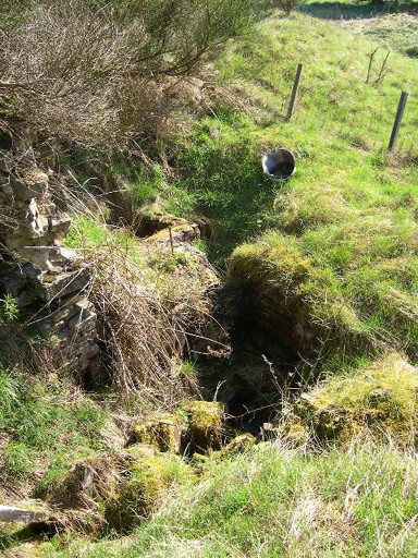
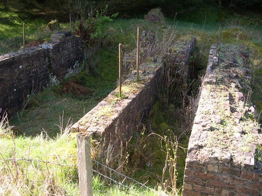
In July 2008, Peter Hall kindly sent a couple of his photographs taken of the remains of workings at the Rameldry No. 1 Pit site.
 |
 |
-------------------------------------------
| Source Date of Information Supplied |
|---|
| Manager / Under-Manager / Men underground / Men above ground / Coal seams worked |
| 1873 (J. Thomas) |
| 1890 (James Martin) |
| James Martin / ------------ / 22 / 6 |
| 1896 (James Martin) |
| James Martin / ------------ / 24 / 5 / Manufacturing coal. |
| 1902 (James Martin) |
| W. Maxwell / ------------ / 12 / 2 / Manufacturing coal. |
| 1904 & 1905 (James Martin) |
| W. Maxwell / ------------ / 14 / 2 / Manufacturing coal. |
| 1908 (James Martin) |
| W. Maxwell / ------------ / 18 / 2 |
| 1911 (James Martin) |
| W. Maxwell / ------------ / 14 / 2 |
| 1918 (James Martin) |
| W. Maxwell / W. Wilkinson / 13 / 2 |
| 1920 (James Martin) |
| Manpower: 14 / 3 |
| 1928 (Cults Lime) |
| George Bryson / ------------ / 13 / 3 / Manufacturing coal. Blind. |
Information on coals worked at, or near, Rameldry Pits
(based on a report from 1900)
The seams that occurred in the Rameldry field were invaded by whinstones so that the coals in parts of the field were rendered useless and unworkable. A section of the seams in the small Rameldry coalfield are given in the following section of the strata:
| UPPER OR MAIN COAL, with 1½ in. middle parting | 3 ft. 6 in. |
| Strata | 60 ft. |
| SMITHY COAL | 1 ft. 9 in. |
| Strata | 24 ft. |
| PARROT COAL, with 2 in. of soft coal | 4 ft. 2 in. |
| Strata | 60 ft. |
These seams were disposed in the form of the segment of a
basin where the remaining lip circled round from Bowden Hill,
on the north-east to the ridge of Parkwell, on the
south-west.
The outcrop of the Parrot Coal and Smithy Coal seams lay
close to the top of the whinstone sill that came in at
Parkwell. It then turned north-eastward by Coaltown of
Burnturk to the flanks of another great mass of dolerite that
stretched from Bowden Hill for two and a half miles to the
south. The field was crossed by a dyke and fault that ran
between the two igneous masses from Honeyhall towards
Parkwell, and on the south side of this interruption, the
coals came in again with a southerly dip, but their further
progress in that direction was only revealed towards the end
of the nineteenth century when they were worked at these pits
in the southern part of the field, all that part lying to the
north of Rameldry, i.e. Burnturk, Downfield and Coalpitden,
being either exhausted or too poor to be mined.
The Parrot Coal seam south of Burnturk was another example
of a coal becoming "blind" or anthracitic, no doubt
in consequence of the action of igneous intrusions upon it.
Two seams of blind coal are believed to have been worked from
the Rameldry Pits. These were formerly supposed to lie below
the Parrot Coal, but they are now regarded as more probably
the Smithy Coal and Parrot Coal seams in an altered
condition.
[The exact position of these seams in the coal series of
Fife has not been ascertained.]
| Plans of Abandoned Seams for Rameldry | Pits or Mines designated in Plans |
|---|---|
| COAL; unnamed seam (1850) | Rameldry |
| COAL; probably Main (1900) | Rameldry Nos. 1, 2, 3, 4 |
| COAL; Main; Little (February, 1906) |
Rameldry Nos. 1, 2, 3;
Old No. 1 or Moss; Old No. 2 |
| COAL; Blind (December, 1920) | Rameldry |
| COAL; probably Main (1925) | Rameldry No. 1 |
| COAL;
Upper and Lower Blind
or Main (April, 1931) |
Rameldry |
Footnote
The names Coalpitden and Coaltown of Burnturk leave no
doubt that this small region of the county played an
important role in the early coal industry. The coal-pits of
Burnturk, Downfield and Rameldry were at the centre of a
local lime burning industry near Cults from around the
beginning of the nineteenth century when limestone was
transported from quarries or mines to kilns. One writer has
stated that burnt lime and coal were sent to Kingskettle by a
small canal system in the Burnturk area, and that they were
the only industrial canals of any consequence in the whole of
Fife.
To date we have not uncovered any information to verify the
existence of these canals. Can you help?
--------------------------------------------
"Dunfermline Journal"
22 February, 1873
KINGSKETTLE - SERIOUS ACCIDENT
On Tuesday, about midday, John Pratt, a collier, employed at the colliery of Mr Martin of Priestfield, near Clatto, was putting up a number of props to support the roof, when, a portion, weighing 2½ tons, gave way unexpectedly and fell, crushing him rather severely.
--------------------------------------------
Mines Inspectors Report - 1907
by Mr. Robert McLaren
Appendix III.
Abandoned Plans - Rameldry - Main Coal.
--------------------------------------------
