|
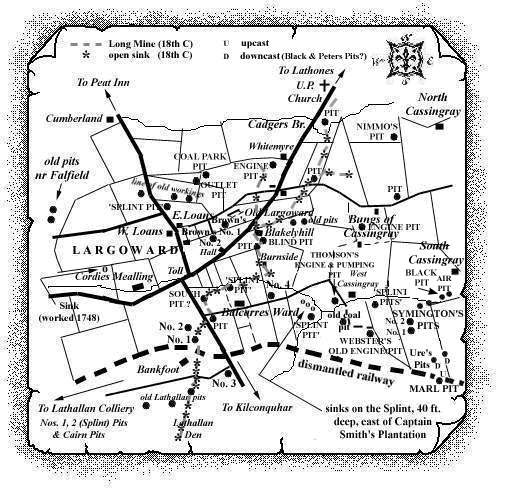
This 19th century pit, stated to have been sunk in 1860 to a
depth of 95 fms. to the south-west of North Cassingray, may have
been in existence for a very short time. An unidentified source has
provided a description of an attempt to inspect the former site of
the pit in the 1950s.
He states that he, "... only discovered the ruins of a
small stone building on the west side of a dyke. There was no
evidence of any bing. I was told by an old local miner that a pit
had been sunk here and that the ruin was that of an old winding
engine house. He had heard that the pit was not worked due to lack
of funds after sinking."
Click on Map to Zoom In
A section of a boring, sunk less than half a mile to the
south-west of the location of Nimmo's Pit and indicated on an
early plan, suggests that the Black Coal seam was at the bottom of
Nimmo's Pit.
A full representation of the information from the plan is given
below:
| Description |
Thickness |
| Strata |
102 ft. |
| Limestone [Upper Kinniny or Top Hosie] |
1 ft. 8 in. |
| Strata |
30 ft. 6 in. |
| Parrot Coal (foul) |
2 ft. |
| Strata |
6 ft. |
| Whinstone (hard) |
24 ft. |
| Strata |
12 ft. |
| Coal |
6 in. |
| Strata |
46 ft. |
| Parrot Coal } Largoward |
6 in. |
| Splint Coal }
Splint |
3 ft. 9 in. |
| Strata |
72 ft. |
| Coal }Black Coal |
4 ft. |
| Strata |
1 ft. 6 in. |
| Coal (foul) }Lower Coal or Scarrat
Loft |
46 ft. |
| Strata |
3 ft. 1 in. |
| Coal |
9 in. |
| Strata |
7 ft. 9 in. |
| Coal |
9 in. |
| Strata |
65 ft. 8 in. |
| Coal |
5 in. |
| Strata |
169 ft. 11 in. |
| Limestone & partings [Mid Kinniny
Limestone] |
7 ft. 5 in. |
| Strata |
26 ft. 1 in. |
| Coal (pelts of coal) } Bottom Marl |
1 ft. 6 in. |
| Coal (very foul)
}
Coal |
1 ft. |
| Strata |
1 ft. 3 in. |
| Coal (foul) |
2 ft. 7 in. |
| Strata |
17 ft. 9 in. |
| Parrot Coal (Bastard) |
1 ft. |
| Ironstone |
4 in. |
| Coal |
1 ft. 7 in. |
| Coal (foul) } Main |
2 ft. |
| Strata
}
Coal |
1 ft. 1 in. |
| Coal (hard) }
? |
2 ft. 9 in. |
|
See Cassingray Colliery entry -
East Fife Index. |
|