Owners: Mr. James Thomas (1854-59?)
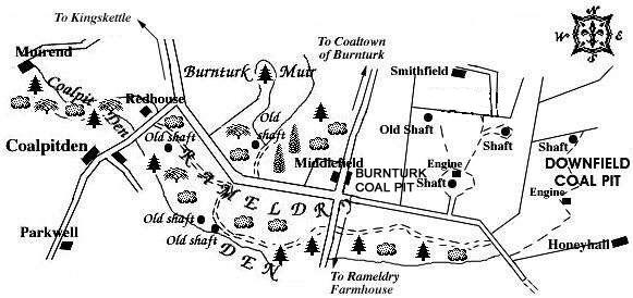
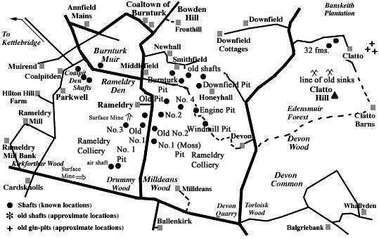
Downfield Coal Pit lay south-east of Coaltown of Burnturk and north-east of Rameldry Den. It was located in the field immediately east of the Burnturk Coal Pit, with a working shaft and engine shown on a source dated 1856. It is not known when the small pit first opened or when it finally closed but possible dates are ca 1800-1859.
 |
 |
Coals worked at, or near, Downfield Pit, nr Rameldry
(based on a report from 1900)
The small Rameldry coalfield to the south-east of Kettlebridge had been brought down by a large fault against Calciferous sandstones and had been greatly invaded by eruptive rocks rendering the coals in parts of the field useless and unworkable. The coal seams that occurred in the vicinity are shown in the following section of the strata:
| UPPER OR MAIN COAL, with 1½ in. middle parting | 3 ft. 6 in. |
| Strata | 60 ft. |
| SMITHY COAL | 1 ft. 9 in. |
| Strata | 24 ft. |
| PARROT COAL, with 2 in. of soft coal | 4 ft. 2 in. |
| Strata | 60 ft. |
These coal seams were disposed in the form of the segment
of a basin where the remaining lip circled round from Bowden
Hill, on the north-east, to the ridge of Parkwell, on the
south-west. The outcrop of the Parrot Coal and Smithy Coal
seams lay close to the top of the great whinstone that came
in at Parkwell. It then turned north-east, by Coaltown of
Burnturk , to the flanks of another great mass of whinstone
that stretched from Bowden Hill for two and a half miles to
the south. The field was traversed by a dyke and fault that
ran between the two igneous masses from Honeyhall towards
Parkwell. On the south side of this interruption, the coals
came in again with a southerly dip, but their further
progress in that direction was not certain approaching the
final decades of the nineteenth century.
The Parrot Coal seam south of Burnturk afforded another
example of a coal becoming "blind" or anthracitic,
no doubt in consequence of the action of igneous intrusions
upon it. Two seams of blind coal were apparently worked from
the Downfield and Burnturk Pits in the angle between the main
mass and the projecting tongue of whinstone. These were
formerly supposed to lie below the Parrot Coal, but they are
now regarded as more probably the Smithy Coal and Parrot Coal
seams in an altered condition.
[The exact position of these seams in the coal series of
Fife was not ascertained at the time of publication of the
report.]
