Owners: Alexander Murray of Ayton (early
18th C)
Alexander Low (Lessee) ca 1755
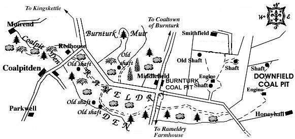
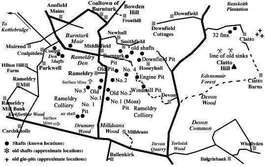
Coalpitden - a great-sounding little place that could only mean what it says - a den of coalpits! Lying to the south-west of the Coaltown of Burnturk, nearly two miles east of Kingskettle, a group of four old shafts - three to the south, and one to the north, of the road running by Coalpit and Rameldry Dens - are clearly marked on a mid-nineteenth century map of the area also displaying the working coal-pits of Burnturk and Downfield a mile further to the east. Sadly, there are no signs of these pits in the fields today.
In the first Statistical Account of the parish of Kings Kettle, we find "... In Barntark Muir, the surface of which is a common, and covered with heath, coals have long been procured. These mines, which are the property of Alexander Murray, Esq; of Ayton, have been let, for the last 40 years, to Alexander Low, Esq; who is now seriously engaged in attempting to obviate those inconveniences which have hitherto impeded the working. The coals are of a superior quality, most of them resembling the oily Newcastle coal. There is another stratum of coal, but inferior in quality, at Dovan, belonging to Dr Pitcairn. Coals have also been procured at Clothie, an estate belonging to Mr Balfour. Some time since, when sinking a shaft to discover the extent of the coals, some metallic ores were discovered, which have not as yet been essayed. ...".
[Dovan = Davan? and Clothie = Clathie? estates (as yet not identified but perhaps the present Devon farm and Clatto.)]
There were, in 1791, 78 people living in Coaltown of
Burnturk and of those 12 were colliers. It is further
observed that "Kettle possesses very material
advantages in its coal and lime works". By the time
of the second Statistical Account (1845), most of the coal
used in the parish (for burning lime) was brought from
Balbirnie.
"...Coals also used to be dug up in Burnturk; but
these are now mostly given up, excepting a blind coal, which
is used for burning lime, and is mostly carted off to
Pitlessie lime-hills. Some ironstone also is found in the
parish. ..."
 |
 |
Coals worked at, or near, the Coalpitden Pits
(based on a report from 1900)
This isolated tract of coal-bearing rocks, brought down by a large fault against the Calciferous sandstones, is known to have been invaded by various whinstones rendering some coals in parts of the field useless and unworkable. The coal seams that occurred in the small Rameldry Coalfield are given in the following section of the strata:
| UPPER OR MAIN COAL, with 1½ in. middle parting | 3 ft. 6 in. |
| Strata | 60 ft. |
| SMITHY COAL | 1 ft. 9 in. |
| Strata | 24 ft. |
| PARROT COAL, with 2 in. of soft coal | 4 ft. 2 in. |
| Strata | 60 ft. |
These coal seams were disposed in the form of the segment of a basin where the remaining lip circled round from Bowden Hill, in the north-east, to the ridge of Parkwell, in the south-west (see area map above).
The outcrop of the Parrot Coal and Smithy Coal seams lay close to the top of the whinstone intrusion that came in at Parkwell and it is these outcrops, in the Dens, which are likely to have been wrought from these old mines and bell pits which were in existence from the mid-eighteenth century until probably the 1820s. The Parrot Coal seam to the south of Burnturk is recorded as having become "blind" or anthracitic, presumably by the action of the whinstone intrusions upon it.
