Owners: Newark Coal and Salt Company
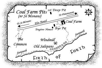
Two 18th century pits are known to have been located
between St. Monans and Pittenweem on either side of the
present A917 just yards to the west of the site of the
present day Coal Farm. A plan from 1789 shows what appears to
be the 1st Deep Pit sunk to 35 fathoms on the north
side of the Elie Road and linked underground to the Bye
Pit to the south of Elie Road which appears to have
reached a depth of 30 fathoms. The engine house of the Bye
Pit is also indicated on this plan just yards to the west of
the pit. [A description of the information on this plan is
given later in this entry.]
Statistical Accounts suggest that this Coal Farm pit, the
property of Sir John Anstruther, was sunk not far from a
number of very early coal pits including one known as
Cromwell's Pit. With the assistance of a
fire-engine, Sir John was able to work the deeper coal seams
unable to be wrought in the earliest coal pits which mined
the Parrot Coal of the area.
The colliery was in operation from about 1771 exclusively
supplying coal for the company's salt pans which were
located a few hundred yards south of the pits and close-by
the shore.
Salt, extracted from sea water, was a valuable commodity at
this time, used for preserving fish, meat and other
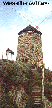
provisions. Nine salt pans were built along the shore at St
Monans and the windmill was used to pump sea water up to the
pans. The water was boiled until it evaporated, leaving a
residue of salt crystals. The coal needed to boil the sea
water came from the pits near Coal Farm. An underground fire
at the colliery in 1794 is known to have seriously hindered
coal production.
Sir John Anstruther, founder of the company, also built a
wooden railway track along which horse-drawn waggons brought
coal from the pits to the salt pans, and carried coal and
salt to Pittenweem harbour. The route of this track is still
known as the "Waggon Road".
Salt-making became increasingly hampered by economic
problems and the St Monans saltpans were abandoned by
1823.
 |
 |
 |
 |
| Windmill | Kellie Castle |
Statistical Account of Fife (St Monance) 1791
"There is an abundance of coal in the lands of
Newark, consisting of splint, cherry, and culm, at present
working. It is not level free, but wrought by a fire-engine.
Likewise one of the neatest and best contrived salt-works
upon the coast, called St. Philip's; both are the
property of Sir John Anstruther, Baronet. The coal and salt,
besides what is sold to the country, are exported at
Pittenweem.
In the lands of Abercrombie there are several seams of coal,
but as yet untouched, and which belong to Sir Robert
Anstruther, Baronet. Coal abounds in this country, both in
the coast and interior parts, and that necessary article for
the comfort of life might be obtained at an easy rate. But
since of late, coal working has become a trade, by opening
only a few at a time, and thus monopolising them, the price
is kept up; and there is no other fuel used, or to be had in
this place. This winter the inhabitants have been greatly
distressed for want of this article, by the difficulty of
obtaining it, and the high price."
 |
| Pittenweem coal-works
- 18th C employee
(full service dates unknown) |
|---|
| James Wilson, coal grieve, at Pittenweem - 1788 |
Statistical Account of Fife (Pittenweem) 1793
"The whole surface of the parish is supposed to cover a continued field of coal, which lies in a very extraordinary way, first taking one direction, then a contrary one, with different dipps. The property of it belongs to Sir John Anstruther. When it began to wrought is uncertain. It is believed to have been wrought by Oliver Cromwell, who took possession of the Earl of Kelly's estate, of which it then formed a part; and a pit is still to be seen, that goes by the name of Cromwell's Pit. In past times, as much coal was taken out as could be procured without a fire engine. After the working had been long discontinued, Sir John Anstruther, about 20 years ago, erected a fire engine, and has since that period put out an immense quantity of coal, and made salt to a large extent. There are 9 salt pans. The average expense for the coal and salt working is about £50 weekly. The colliers are all free, stand engaged by the year, and are paid in proportion to the work they respectively perform. A good and laborious collier will earn about 18s. a-week."
Statistical Account of Fife (St. Monans) 1837
"There are said to be six seams of coal in the
barony of St. Monans, splint and cherry. Those seams range in
thickness from 18 inches to 7 feet. In former times the coal
here was wrought to a depth of ten fathoms; but it had been
given up for twenty-five years, when it was resumed, about
nine years ago, the shafts being driven to the depths of 27
fathoms. For eighteen months, the working of the coal has
been wholly abandoned, owing to the tacksman not having the
capital to meet the requisite outlay, and the engine not
having been judiciously placed. Wrought in an effective
manner, it might have afforded employment for one hundred
persons. It is believed that a person or company of capital
and enterprise, might make the coal here a very profitable
concern.
There are understood to be several seams of coal in the
lands of Abercrombie."
---------------------------
Statistical Account of Fife (Pittenweem) 1845
"... This parish forms part of the coal-field of Fife. The mounain limestone, constituting the lowest bed of the formation, is here seen to crop out on the surface to the west of the town, and above this are workable seams of coal. The intrusion of trap rocks has formed an anticlinal axis, so that the seams of coal dip in two directions. The precise period when coal began to be worked in the pits here cannot be ascertained. The tradition is, that a pit was opened up by order of Oliver Cromwell, who took possession of the Earl of Kelly's estate, of which it then formed a part, and this old working still goes under the name of Cromwell's Pit. After the working had long been discontinued, it was recommenced by the proprietor, Sir John Anstruther, about the year 1770 on a large scale, and still continues. An extensive salt manufactory was also established by the same active proprietor; but this has been long ago given up. ..."
---------------------------
Information on coal seams worked at, or near, Coal Farm Pit
(based on a report from 1900)
The best section of the Lower Limestone Group, composed of sandstones and shales, with a few coal seams and ironstones, in east Fife is that which was laid bare by the sea along the coastline from the west end of St Monans to Coal Farm near Pittenweem. Since the rocks there were folded in a "a double synclinal trough", this meant, in simpler terms, that there was a double exposure of the layers at a distance of under one mile between the layers. Detailed studies of this Group, from St. Monans to Coal Farm, in the mid-nineteenth century, revealed a number of coal, and coal-rich, seams within a total of 59 individually-referenced strata.
| Reference No. of strata | Description | Thickness |
| Nos. 1 - 5 | Strata - mainly shales and sandstones | 33 ft. 4 in. |
| No. 6 | COAL - rather coarse and brassy above, splint below | 4 ft. |
| Nos. 7 - 19 | Strata - fireclays, sandstones and shales | 84 ft. 9 in. |
| No. 20 | COAL* - coarse | 2 ft. |
| No. 21 | Fireclay and shale with coaly bands | 9 ft. |
| Nos. 22 - 38 | Strata - fireclays, sandstones, shales and limestone | 150 ft. 3 in. |
| No. 39 | COAL - coarse | 6 in. |
| Nos. 40 - 42 | Strata - fireclays, sandstones and shales | 7 ft. |
| No. 43 | Fireclay and shale - dark and coaly | 2 ft. |
| No. 44 | COAL | 4 in. |
| Nos. 45 - 49 | Strata - fireclays, sandstones, shales and limestone | 20 ft. 3 in. |
| No. 50 | Dark shale (a coal about 2 ft. thick had been worked here, and the 'stoops' were apparently left in position) | 2 ft. |
| No. 51 - 55 | Strata - fireclays, shales and sandstones | 20 ft. |
| No. 56 | COAL - hard and coarse | 6 in. |
| Nos. 57 - 59 | Strata - fireclay, limestone and shale | 28 ft. 6 in. |
* The full thickness of this coal seam was apparently no longer visible on the beach around 1900 where it was probably quarried away for domestic use in a much earlier period. It appeared to be the same coal seam known locally as the "Harbour Coal", reported to have been 6 ft. thick, which cropped out in the old harbour of St Monans and which was formerly worked in this little coalfield. The 4 ft. thick coal seam lying above the "Harbour Coal" is also reported to have been worked here.
| Plans of Abandoned Seams for St Monans | Pits or Mines designated in Plans |
|---|---|
| COAL; Cherry | St Monans (District) |
The above abandonment plan indicates the ground worked as the Common and foreshore close to the Old Windmill at St. Monans just south of Coal Farm pit.
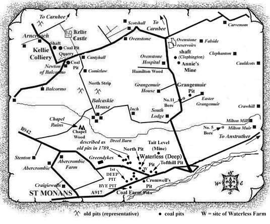
Early Pittenweem Coal Works Plan - 1789
"It has been our pleasure to view a copy of a
plan sent in by one of our regular contributors. The plan is
believed to date from 1789 but unfortunately there are
several pieces of text that cannot be made out on the
copy. However, knowing that many of our regular
visitors are very interested in the very early coal works of
Fife, we have provided the following description of our
observations.
Please refer to the sketch map above."
M. Martin & Webmasters
"The Colinsburgh or Abercrombie Road which forms a
fork with the Elie Road, runs in a NW-SE direction. The
formation of the present-day road junction between Elie and
Pitenweem has not changed significantly from that shown on
the 1789 plan and when visiting friends in Crail, I still
take the Abercrombie Road to join the Tofthill Road although
this area is now known as Crofthill, rather than Tofthill, on
modern OS maps.
Several of the old pits are north of the Elie Road which
becomes the Tofthill Road heading east towards
Pittenweem.
The plan has information panels with the following texts (not all clear on the plan copy):
"Sketch of the Surface of the Pittenweem Lands
where the coal has been wrought by Sir John Anstruther of
Anstruther, and is now working by him; and of the working of
the said coal under the Lands belonging to Sir Robert
Anstruther; and the lands adjoining them(?) do made by
me.
In obedience to an Interloquelor(?) pronunced by Lord
Stonefield(?) Ordinary to the conjuned(?) processes of
Suspension(?) and declarilor(?) between the said Sir John
Anstruther, and Sir Robert Anstruther.
Gavin Hogg"
"The Lands belonging to Sir Robt Anstruther are all marked; All the other lands lowest(?) this & the Lands lowest(?) the Standing Stone belong to Sir John Anstruther."
There is a Standing Stone clearly visible on the plan to the north-east of Tofthill fields, and east of the 'Surface Sunk by the old workings in the coal'. This is east of the Deep (Waterless) Pit which is sunk by the side of the Colinsburgh or Abercrombie Road. The words 'lead room in the Parrot Coal' are to the east of the Deep (Waterless) Pit whose stoop-and-room workings stretch eastwards and westwards underneath the afore-mentioned road. The workings to the east stop short of an area called 'The Crooked Deals' which is just north-west of the Standing Stone. Adjacent strips of land in this area, moving eastwards, are labelled as belonging to Sir Robt. Anstruther, Sir John Anstruther and Pollock, respectively.
North of 'The Crooked Deals' there is what looks like 'Tait Level or mine wrought by the Earl of Kelly' running in a north-south direction and crossing a waggon road which runs west-east in that area.
To the west, along this waggon road, there appears to be
written 'Tract of a cast made by Earl of Kelly to
carry the water of the Burn'.
[A cast was a drainage ditch or channel, and the Burn
referred to is likely to be the Dreel Burn, or a small
tributary of this, which lay just a few hundred yards to the
north.]
To the north of this text is indicated 'Moor belonging
to the Town of Pittenweem'.
To the south of the waggon road mentioned earlier, which joins another section of waggon road running in a north-south direction with the North Pit and the Deep (Waterless) Pit lying to the east of this section of waggon road, there is what looks like a line of old pits. I cannot make out the first word in the text which looks like 'outliage(?) of old pits'.
The North Pit (written as North Pitt) is near a horse-shoe shaped working indicated in two places as 'Level in Parot Coal' and 'Level in the Parot Coal'. The area immediately north of these levels, but south of the line of old pits, is called 'The Long Deals'.
There is an unnamed pit just yards to the west of the Deep Pit at the northern edge of the stoop-and-room workings which run westwards for several hundred yards going towards the 'Coall Pitt Moor'. This moor is also indicated on the south side of the Elie Road where the moor is crossed by the waggon road leading down to the coast by the Firth of Forth. This is the section of waggon road which runs north-eastwards from the coast up towards the Deep Pit which then turns to the north past the North Pit.
To the south of the Deep Pit, and south of the Abercrombie Road, there are stoop-and-room workings and further south some old workings are marked along with some comment about a ' ...... seam of a Sour Coal'.
To the south, on the sea-side of Elie Road, is the old pit known as 'Cromwell's Pit' with the comment ' .. said to be a horse gin pit in Cromwell's time'. A few yards to the west of this pit is a symbol which could be that of another old shaft but I have not placed this one on the website map. Another two old shafts (both unnamed) are shown in the area between The Coall Pitt Moor (north of the Elie Road) and what looks like 'The Pipes' or 'The Piper' south of another 'old pit' lying between two areas of stoop-and-room workings in the Parot Coal.
Most interestingly, there appear to have been two pits operating near what became Coal Farm. The Bye Pit, at what appears to be 30 fathoms, is close to the engine house in the St. Monance Lands south of the Elie Road. Linked underground (I believe) to a pit which appears to be called the 1st Deep Pit at 35 fathoms, on the other side (north side) of the Elie Road.
Sir Robert Anstruther's lands to the north of the Coall Pitt Moor are indicated and a waggon road, running north from the western end of the stoop-and-room workings (a pit nearby), towards the lands of Greendykes - an old farm steading now long gone - is clearly indicated. This waggon road crosses the Abercrombie Road and after travelling north for a few hundred yards, it curves around to the east making its way towards the town of Pittenweem. The waggon road running northwards past the Deep Pit and the North Pit also curves round in an easterly direction to join this waggon road heading eastwards.
By the start of the waggon road and old pit leading up
towards the Greendykes lands, there is text which I cannot
make out - it looks like 'Seals of the
Blowerman(?)' and I wonder what this is about?
A short distance to the west of this waggon road is another
piece of text which looks like 'The Old Casl'
but this may be 'Cast' which is Scots for a
drainage channel or ditch or passageway. 'The Old
Cast' continues in a north-westerly direction from
the northern side of Abercrombie Road and must have passed
closed to Greendykes steading on its eastern side.
Interestingly, in the lands of Sir Robert Anstruther, lying between the two north-running sections of waggon roads, there are four old pits, grouped in two pairs and just a short distance apart. The text by the most northerly pair of old pits reads 'Pits made by ..........(?)' and by the two old pits to the south, just 'Two old pits'. Some text just to the east of this is unreadable but symbolism on the plan suggests that it may refer to another old pit, or pits.
Roads and pathways by the Brae Head, between the coast and the Elie Road, are also indicated in the southern part of the plan which indicates that Sir Robt. Anstruther's lands are under the Braes.
A piece of land is also outlined in the south as 'Sir Robt Anstruther acquired from Jas. or Oliver Stocks and now ...........(?) by Mrs(?) Sime(?).
------------------------------------------
"Fifeshire Journal"
25 July, 1839
COAL AND IRONSTONE IN THE EAST
OF FIFE
TO LET
THE COAL in the PITTENWEEM and ST MONANCE
ESTATES, consisting of various Seams, of from three to twelve feet
thick. This Coal was formerly worked by an Engine to the depth of
thirty-seven fathoms, but there is reason to believe that there is
still a considerable quantity remaining unwrought within the
Lands.
The Coal is of excellent quality and much in
demand, and it is understood that there is Ironstone also within
the Lands. There is a right of Railway from the Pits to the Harbour
of Pittenweem, at a short distance. The Proprietor will be ready to
receive proposals for a Lease, for such number of years as may be
agreed upon.
Such information as the Proprietor is possessed
of will be furnished by MR JOHN WILLIAMSON, Engineer, Viewfield, by
Dalkeith; and proposals for a Lease will be lodged with him, or
with MR H. G. DICKSON, 5, St Vincent Street, Edinburgh.
------------------------------------------
The "Fifeshire Journal" issues of 13 and 27 March, 1845, carried advertisements almost identical in wording to the one above.
------------------------------------------
"Fifeshire Journal"
1 November, 1849
PITTENWEEM
COAL AND IRON MINES
A rumour is afloat that the coal mines have been
sold; - we have made inquiry on this interesting subject, and
believe the matter to stand thus:-
A Company have offered the proprietor a large
sum for the estate on which the coal is situated, and that the
proprietor has accepted the offer; but the turning over of the
property must have the sanction of the Court of Session, which will
assemble in Edinburgh next month. Whether there is any legal
difficulty to be got over connected with the law of entail we do
not know; but if there is any doubtful point we hope it will be
given in favour of the Company, if their Lordships understand that
constant employment for 500 men is at stake, and the exportation to
foreign countries of thousands of tons of coal annually, - it being
the best coal in Scotland for export - and thereby enriching the
kingdom at large.
Pittenweem Register
------------------------------------------
"The Scotsman"
13 July, 1891
ANSTRUTHER COALFIELDS. - A petition is being largely signed in the East Neuk of Fife, addressed to Mr Baird of Elie, asking him to grant a lease of the coalfields between Pittenweem and St Monans to a limited liability company, with a capital of £50,000. The petition says that, seeing that the fishing industry had for years past been retrograde, and that the trade in the district had reached its lowest ebb, it had become imperative that some other industry should be commenced in the locality in order to revive trade.
------------------------------------------
"Dunfermline Press"
1 August, 1891
ANSTRUTHER - DISCOVERY OF A NEW COAL SEAM
While workmen were engaged in draining St Monans Moor to the east of the town last week, they came upon a seam of cherry coal two feet thick, and of good quality. They also passed through part of the old workings of Pittenweem and St Monans coalfields, which were last wrought in the beginning of the century. There is every appearance of abundance of coal in the district.
------------------------------------------
"Dunfermline Press"
2 June, 1894
THE PROPOSED RE-OPENING OF THE
PITTENWEEM COAL FIELD
On Thursday, the Town-Clerk of Pittenweem
received a letter from Mr Baird, of Elie, in answer to a
numerously-signed memorial from inhabitants in the coast burghs
from Crail on to Earlsferry, asking for the re-opening of the
coal-fields between Pittenweem and St Monans, and Mr Baird
expresses his willingness to do his utmost to advance the
prosperity of the district, and says he will take part in a remit
to an experienced mining engineer, to be mutually chosen, to report
on the extent and character of the coal in the fields, and whether
they can be worked to profit. The half of the expense will be borne
by him. The reply is considered as very satisfactory by the
Committee in charge of the movement, and they are likely to agree
to Mr Baird's terms.
The fields have been closed since the beginning
of the century.
------------------------------------------
"Cowdenbeath & Lochgelly Times & Advertiser"
24 April, 1895
MINING IN THE EAST OF FIFE
On Friday evening the committee in charge of the project for re-opening the coal pits between Pittenweem and St Monans met in the Town Hall to hear the report submitted by Mr Galloway, M.E., Cardiff, who lately visited the district and surveyed the ground. Mr Galloway deals in an exhaustive manner with the geological aspect of the district, and then says the colliery was worked for generations before last century. It was stopped about 1803.
The amount of coal taken out of the pits would certainly not be more than 3,200,000 tons. The aggregate thickness of the seams is 42 ft, and the coal to be got still would amount to 9,249,000 tons, or sufficient to maintain an output of 150,000 tons a year for 60 years.
It would take about a year to pump out the water, and the necessary plant for this would cost £6085. The cost of a colliery with one shaft 14 feet in diameter by 140 yards deep, and one shaft 10 feet in diameter by 140 yards deep, provided with all the necessary machinery, plant, and appliances, including railway sidings necessary for dealing with an output of 500 tons per day, would not exceed £16,000.
The cost of working the coal ought to not to exceed 5s 6d per ton, inclusive of royalty and all other charges.
Mr James Todd, barrister, London; Mr Cook, solicitor; ex-Provost Gilchrist, and others expressed satisfaction at the extremely favourable character of the report, which greatly exceeded their expectations. It was unanimously agreed to forward a copy of the report to Mr Baird of Elie, the proprietor, and ask whether he would be agreeable to lease the colliery, or what his intentions were in the matter.
------------------------------------------
"The Scotsman"
13 May, 1895
PITTENWEEM COALFIELDS. - A reply has been received from Mr Baird, of Elie, acknowledging receipt of the report by Mr Galloway, M.E., Cardiff, on the coalfields, with which he expresses himself satisfied, and states that he will be prepared to give his best consideration to any proposal which he may receive from any one of means and practical ability to work the coal.
------------------------------------------
