Coal was formerly worked to the north and north-east of the village of Colinsburgh, which lies less than two miles south of the old Rires coalfield.
 |
 |
Information on coals worked around Colinsburgh
(based on a report from 1900)
The strike of the Earlsferry coals, when continued, would have carried their outcrop north-westwards under the links of St Ford. However, somewhere through this hollow ran the great boundary fault of the Pittenweem coalfield. As a result of this fault having a considerable downthrow to the south, the outcrops on the north side of it lay to the west of their trend on the south side.
A boring put down near Muircambus, probably on the north side
of this fault, passed through no fewer than 21 seams of coal before
it stopped at a depth of 58 fathoms!
These seams varied from 4 in. to 2 ft. 5 in. and, at the bottom
of this bore, a seam 3 ft. 5 in. was encountered. They were probably
continuations of the Earlsferry coals but, if so, they showed a
considerable falling off in thickness during their course of less
than 1½ miles to the north-west.
A little further east another bore, sunk on the east side of the
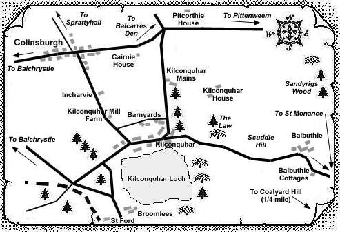
road a few yards to the north of Kilconquhar Mill farm, passed
through several limestones and stopped in a hard limestone at 34
fathoms 2 feet 11 inches. These limestones were probably the lower
group which underlie the Edge coals. One of them, which was found
at a depth of 20 fathoms and described as "light and extra
hard", was 11½ ft. thick, and may possibly have been
the Hurlet seam.
A sheet of whinstone nearly 14 ft. thick was
pierced not far below the surface and beneath it was found a seam
of coal measuring 2 ft. 2 in. thick, but "burnt useless".
Four coal seams were described as striking in a north-easterly direction about a quarter of a mile beyond Colinsburgh, and dipping towards the north-west. Beneath them, the Hurlet Limestone was 14 ft. thick. It was formerly quarried in this area and could be seen in the ravine above Pitcorthie House.
The lowest coal, known as the Marl seam, consisted of a lower band 3 ft. thick separated from an upper band, which was 2 ft. thick and very soft, by a parting of "marl".
The second coal had a thickness of 3 ft., the third coal was named the 'Two-feet Splint', and the fourth coal the 'Six-feet Splint'.
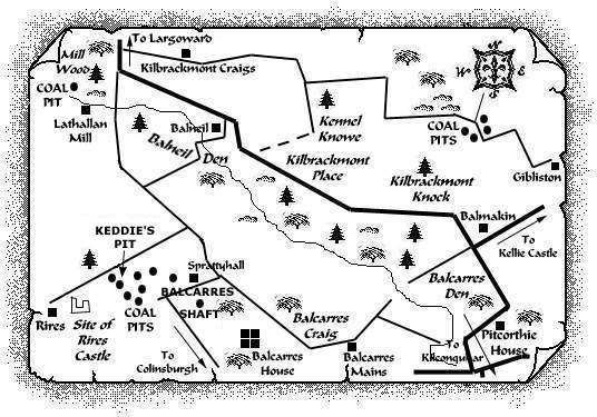
The 'Two-feet Splint' was apparently worked under the dolerite sill of Balcarres Craig which is thought to have been injected between this seam and the Six-feet seam, the latter having its dip increased to 20o by the intrusive rock. The upper seam, lying on the north side of the sill and dipping under the Rires coal-basin, was also known to extend in a north-easterly direction, towards Gibliston, not exactly parallel with the other coals, as its course was interrupted by the igneous intrusion, and that it passed under the overlying trap of Kilbrackmont Knock and Kilbrackmont Craigs and was worked under it.
The other three coals were found to be greatly
disturbed by intrusive material as they approached Balmakin, but
beyond there they were followed with less interruption
north-eastwards between the outcrop of the limestone and the great
sill lying to the north.
The 'Two-feet Splint' coal is said
to have been worked under the sill at Baldutho, north-east of
Gibliston, but beyond that point no information has been obtained
as to the further course of these coal seams.
---------------------------------------------------
"Fifeshire Journal"
26 December, 1835
COLINSBURGH
We are glad to observe that the Balcarres family, with its wonted benevolence, is distributing liberal supplies of coal to the poor in this neighbourhood.
---------------------------------------------------
