Owners: 1800 (Mr. Alexander Low)
1842 (Mr. D. Thompson)
1854-59? (Mr. James Thomas)
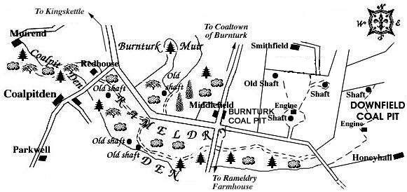
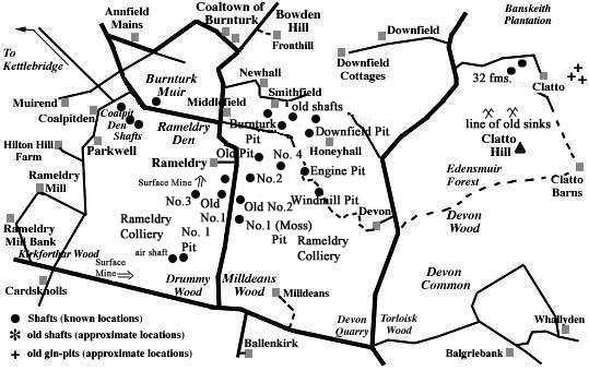
Burnturk Pit lay just south-east of Coaltown of Burnturk
and north-east of Rameldry Den. It was sandwiched between the
area locating the old bell pits of Coalpitden, to the west,
and Downfield Pit, in the neighbouring field, immediately to
the east.
Two working shafts, one old shaft and an engine are revealed
at Burnturk Pit on a map from 1856 indicating, here, deeper
mining than took place in the bell pits of Coalpitden.
 |
 |
It is not known exactly when Burnturk pits first opened or
when they finally closed but possible dates are ca 1790-1859.
Sadly, there are no traces in the fields today that
this area was once extensively mined.
Some coals obtained in this area were apparently of superior
quality, similar to Newcastle coal, but there were also
strata of inferior coals at Davan and Clathie estates (as yet
unidentified but perhaps the present Devon farm and Clatto).
There were, in 1791, 78 people living in Coaltown of
Burnturk and of those 12 were colliers, it being observed
that "Kettle possesses very material advantages in
its coal and limeworks".
From Statistical Accounts: Parish of Kings Kettle (1791)
"... In Barntark Muir, the surface of which is a common, and covered with heath, coals have long been procured. These mines, which are the property of Alexander Murray, Esq; of Ayton, have been let, for the last 40 years, to Alexander Low, Esq; who is now seriously engaged in attempting to obviate those inconveniences which have hitherto impeded the working. The coals are of a superior quality, most of them resembling the oily Newcastle coal. There is another stratum of coal, but inferior in quality, at Dovan, belonging to Dr Pitcairn. Coals have also been procured at Clothie, an estate belonging to Mr Balfour. Some time since, when sinking a shaft to discover the extent of the coals, some metallic ores were discovered, which have not as yet been essayed. ...".
From Statistical Accounts: Parish of Cults (1791)
"... There were coal mines sometime ago upon the estate of Bonzion; which were employed chiefly for burning lime. They might still be wrought to advantage. ... The common fuel is coal from Balbirnie, or Balgonie, which costs at the hill 7d. per load, besides 2s. 3d. per cart for carriage. ..."
From Statistical Accounts: Parish of Kings Kettle (1836)
"...Coals also used to be dug up in Burnturk; but these are now mostly given up, excepting a blind coal, which is used for burning lime, and is mostly carted off to Pitlessie lime-hills. Some ironstone also is found in the parish. ..."
From Statistical Accounts: Parish of Cults (1838)
"... Several alternating beds of coal, shale, and
sandstone repose upon the limestone strata. One of the beds
of coal is twelve inches thick, and may be considered as the
lowest of the whole series, of which the coal-field in the
county is composed. From the quarry it may be traced
westwards to Front-brae, where it may be seen cropping out
along the road which leads to Coaltown. Here the whole series
have been thrown down several hundred feet, underlying the
Burnturk coal metals, and again emerging at Forthar limework
in the parish of Kettle. The other beds of coal vary from a
few inches to about a foot in thickness, and are not
considered of sufficient value to be wrought. ... The whole
of these alternating beds of coal, shale, sandstone and
mountain limestone, have been elevated to the height of about
600 feet above the level of the sea, and now constitute what
are called the Cults or Pitlessie Hills, being apparently a
continuation of the Lomond range. ...
...The coals for burning the lime are brought principally
from Teasses, in the parish of Ceres, a small quantity from
Burnturk, in Kettle, and from Kilmux, in Leven parish.
Coal Mines. - There were coal mines wrought, about fifty
years ago, on the southern declivity of the Cults hill.
These, however, have ever since been neglected, it being
doubtful whether they could be wrought to any advantage.
There are several beds of coal reposing on the lime strata.
One of these is twelve inches in thickness, and the coal is
obtained from it in the process of tirring [mining] for the
limestone. I have just learned, while engaged with this
Statistical Account, that a bed of parrot coal has been
discovered, from 1 to 2 feet in thickness, cropping out
between the two uppermost of the four strata of limestone. Of
what extent this seam of coal may be, has not yet been
ascertained. ...
Fuel. - The fuel principally used is coal, brought for the
most part from Balbirnie, in the parish of Markinch, about
six miles on the road to Kirkcaldy. Its cost at the pit is
1s. 3d. per load of 18 stone. ...
ADDENDUM.
While these pages have been passing through the press, I
have been informed by Dr Anderson of Newburgh, to whom I am
indebted for the geology of the parish, that an omission
occurs in the series of deposits, as described by him, and
that, immediately after the second paragraph in which the
yellow sandstone is noticed, several other beds should be
stated as following in the order of superposition.
Immediately above the yellow sandstone, a series of
alternating beds of sandstone, coal, ironstone, and shale
occur. There are two thin seams of coal, the lowest of which
may be observed cropping out at the farm steading of
Cults-Dam, and the other beds have been quarried about a mile
to the westward. ..."
--------------------------------------
Information on coals worked at, or near, Burnturk Pits
(based on a report from 1900)
The small Rameldry coalfield lay about a mile to the south-east of the village of Kettlebridge, where it had been brought down by a large fault against Calciferous sandstones. It had been so much invaded by eruptive rocks that the coals in parts of the field were rendered useless and unworkable. The seams that occurred here are given in the following section of the strata:
| UPPER OR MAIN COAL, with 1½ in. middle parting | 3 ft. 6 in. |
| Strata | 60 ft. |
| SMITHY COAL | 1 ft. 9 in. |
| Strata | 24 ft. |
| PARROT COAL, with 2 in. of soft coal | 4 ft. 2 in. |
| Strata | 60 ft. |
These coal seams were disposed in the form of the segment
of a basin where the remaining lip circled round from Bowden
Hill, on the north-east, to the ridge of Parkwell, on the
south-west. The outcrop of the Parrot Coal and Smithy Coal
seams lay close to the top of the great whinstone that came
in at Parkwell. It then turned north-east, by Coaltown of
Burnturk , to the flanks of another great mass of whinstone
that stretched from Bowden Hill for two and a half miles to
the south. The field was traversed by a dyke and fault that
ran between the two igneous masses from Honeyhall towards
Parkwell. On the south side of this interruption, the coals
came in again with a southerly dip, but their further
progress in that direction was not certain approaching the
final decades of the nineteenth century.
The Parrot Coal seam south of Burnturk afforded another
example of a coal becoming "blind" or anthracitic,
no doubt in consequence of the action of igneous intrusions
upon it. Two seams of blind coal were apparently worked from
the Burnturk and Downfield Pits in the angle between the main
mass and the projecting tongue of whinstone. These were
formerly supposed to lie below the Parrot Coal, but they are
now regarded as more probably the Smithy Coal and Parrot Coal
seams in an altered condition. [The exact position of these
seams in the coal series of Fife was not ascertained at the
time of publication of the report.]
| Plan of Abandoned Seams for Burnturk Pit | Pits or Mines designated in Plan |
|---|---|
| COAL; Smithy; Parrot (1811) | Burnturk |
--------------------------------------------------
The advertisments in newspapers were a good indication of colliery activity and the current state of the coal trade.
-------------------------------------------------
FIFE'S LOST CANAL - COALTOWN OF BURNTURK
In an Appendix to A General View of the Agriculture of Fife, published in 1800, the Rev. Dr Thomson described the small canal system proposed by the then owner of Burnturk Colliery to link his coal-works with his nearby lime-works.
"On the south side of the road from Cupar to the
New Inn, and about four miles from Cupar, there is a range of
lime-rock, of considerable extent, and of excellent quality
... Within two miles of this rock there is a coalliery
belonging to Mr. Low of Burnturk.
Mr. Low has opened a communication between them (coal and
limestone) by carrying a small canal from his coal-works on
Burnturk, to the bottom of the hill where the lime-rock lies;
along which he means to convey the raw lime-stone to
draw-kills, which he has cut out of a spongy rock, on the
edge of a den close by his coal-pits. This canal is on a
level with the top of his draw-kills. From the bottom of
these kills another canal is cut, extending northwards about
half a mile, till it reach the declivity of the hill, for the
purpose of carrying away the burnt limestone, as also coal
.... When the loaded boats reach the end of this canal, they
are made to pass into skeleton carriages having broad wheels,
and conveyed down the hill, to the side of the highway, near
the village of Kettle, where their contents are to be
deposited in shades (sheds) for the convenience of
purchasers. In passing down the hill they go singly, and are
drawn up, when empty, by horses. But it is intended that
after the first year the loaded carriages shall draw up the
empty ones.
Neither of these canals have occasion for locks, as they are
on a dead level. Both branches are of the same dimensions,
being nine or ten feet broad, and three feet deep. They are
supplied with water from a coal-level, which never becomes
dry; and all surface water is excluded, to prevent the canals
being filled up with mud, which such water may occasionally
bring along with it.
The boats on the different canals are not of the same size.
Those on the upper canal, being used only for carrying raw
limestone, are to be from four to ten tons burden; whereas
the boats on the other are to contain two tons only. His
reason for making these last so small is, that he wishes the
coal and lime conveyed by them not to be broken, but to be
delivered at the shades as entire as when taken from the pits
and kills. To make these boats strong and tight, the seams
are to be covered with thin sheet iron or copper, of two
inches in breadth.
The conveyance of the boats along the lower canal, is to be
effected by means of the boatman's pulling or shoving the
boat by the strength of his arm, exerted on a horizontal
pole, elevated about three feet above the canal, and in the
same line of direction, in the same manner as is practised in
the Duke of Bridgewater's tunnel, where a man pushes from
70 to 100 of our loads of coals at a time. The larger boats
on the upper canal, designed for the raw limestone, are to be
conducted by a man on each side of the canal, pushing a pole
stretched across, and fastened to the leading boat. Thus they
will push or pull, so as to suit the size and windings of the
canal better than a horse, and can do more work than ten
horses on a road in the course of a day."
[Although the remains of a small canal at Burnturk have
been reported as being identified by a group of visiting
naturalists from Kirkcaldy (date not known), others who have
visited the area have found no trace of the canal system as
described above, and we wonder if the proposals for the
venture were just being outlined in the above account but, in
reality, were never fully completed beyond the construction
of a very short 'trial canal', the remains of which
are now difficult to trace?
M. Martin & Webmasters]
--------------------------------------------------
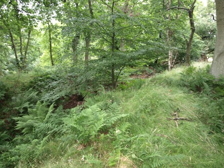
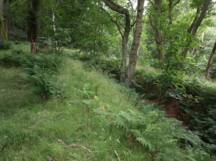
Stephen Bayne has seen the canal traces and revisits the site after nearly half a century.
[Stephen, who contacted us, in July 2013, has given his
permission for us to display his correspondence and photographs
relating to these elusive Fife canals.
M. Martin & Webmasters.]
Dear Mick,
"I came across your very detailed and interesting
website concerning the coalfields of Fife when I googled canals in Fife.
The reason for this search was that I have seen the canals - or the start
of them – that you refer to in your website details. The
downside is that I saw them between Christmas and New Year 1966!!
A wee while ago.
My father was from Ladybank and there was nothing
that he did not know about the region there. He had heard about the canals,
had found a reference to them in a book, and together with a lawyer friend,
who was also interested in local Fife history, they sat down and worked
out where the canals might possibly be.
I shall be back in Cupar from
the end of the first week of August and will try to find them again. It is difficult
to describe, but if I am successful and they can still be distinguished, would
you be interested in my contacting you?
At this stage no promises, but
if my memory serves me correct, one was very easy to identify.
Hope to hear from you when you have time. Enjoy your summer."
Best Regards
Stephen Bayne
[Webmaster, Chris Sparling, took up the correspondence in August. ]
Dear Chris
"I am back in Cupar now and visited the Burnturk area this afternoon.
... What my father and his lawyer friend did all those years ago was to take the
description that they had read – here I am at a loss as to what it was, all 3 of us read.
It may have been an old Fife report or a description of the limeworks and its owner at
Cults. I remember that it was described how the Cults limeworks owner decided to
build a canal from the limeworks to the coalfields at the Burnturk area; use the coal
to work the lime and transfer the finished product to the top of Annfield by a second
canal, and the product would then be transferred to trucks or small wagons. At the
top of Annfield was to be a truck system running on wooden boards down the hill
towards Kettle, in which the full trucks going down would pull the empty trucks up.
Their reasoning was that the 2 canals had to meet where the slope towards the top
of Annfield could take a canal. They found that if they took the 120-metre contour, then
this contour ended above a stream, which would be necessary to fill the canal. This
120-metre contour runs through the middle of the Cults Limeworks, so they reasoned
that the owner planned to excavate a canal to follow the contour. They noticed that the
terrain was fairly flat towards Annfield, so that the second canal, excavated about 5
metres lower, would terminate within reason at the top of Annfield.
As I mentioned in my previous email, the one canal was very obvious, whereas the other
was more vague. I think the landowner started from the "joint" end, but did
not excavate more than about 100 metres. I think that I found the one canal this afternoon,
and the other is more an image of what might have been. The canal is very overgrown,
not so much with trees but with shrubs etc., but I think that the hollowing is manmade.
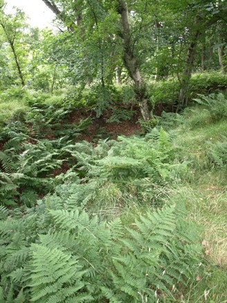
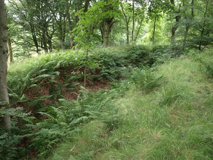
I took some pictures ... I do not know how clear they will be, as all is green! A professional
photographer would know how to turn up the contrast to see the differences. ... I parked
near the slight bend in the road – you cannot go straight into the woods, as it is fenced off,
but going along the side of the fence for about 50 metres, you eventually reach what I
remember I saw those many moons ago.
I will send the pictures when I get the reader. I hope that this might add a little more to your
very interesting story of coalmines in Fife."
Best Wishes
Stephen
--------------------------------------------------
[We are grateful to Stephen for the above information and for permission to display the
photographs (see below).
M. Martin & Webmasters.]
 |
 |
 |
 |
--------------------------------------------------
"The Scotsman"
29 July, 1829
LANDS AND ESTATES IN FIFESHIRE FOR SALE.
To be SOLD, by public roup ... THE ESTATE of HOLEKETTLE and ORKIE
MILN, lying in the parish of Kettle, and shire of Fife, in the following Lots, viz. :- ...
Lot IX. The COAL, METALS, and MINERALS, in the now divided commonty of
Burnturk, consisting of two Lots, commonly called the Main and Blind Coal Divisions,
the boundaries of which divisions are described in the title-deeds. ...
--------------------------------------------------
"The Scotsman"
3 February, 1830
LANDS IN FIFESHIRE.
To be SOLD, by public roup ... PARTS of the LANDS of HOLEKETTLE and BANKTON, in lots, and FEU-DUTIES at Holekettle Bridge, &c. - The LANDS of ANNFIELD. - The MAIN COAL FIELD of BURNTURK, with STEAM ENGINE of 10 Horse Power, Rail Road, Pumps, and other Apparatus, and SUPERIORITY in the County of FIFE to the amount of £94, 14s., all as particularly described in the Fife Herald, and in the Edinburgh, Leith, and Glasgow Advertiser. ...
----------------------------------------------------
"Fifeshire Journal"
21 March, 1839
BURNTURK COLLIERY
There is now an abundant and regular supply of Coal at
this Coalwork - Prices Reduced to 1s. 4d. per
Load for superior Household Coal, and to 8s. 6d. per ton for
good Gas Coal.
20th March, 1839.
----------------------------------------------------
2 May, 1839
BURNTURK COLLIERY
There is now a regular supply of COAL at this Coal-work.
Prices reduced to 1s. 4d. per load for superior
Household Coal, and to 8s. 6d. per ton for good Gas Coal. The
new Pit is this day opened, and the road good and easy.
1st May, 1839.
----------------------------------------------------
13 February, 1840
BURNTURK COLLIERY
THERE is a regular supply of EXCELLENT HOUSEHOLD COAL at
this Work.
12th February, 1840.
----------------------------------------------------
2 April, 1840
BURNTURK COLLIERY
THERE is a Regular Supply of Excellent HOUSE COAL at this
Work. - Price Reduced to 1s. 3d. per Load. Also GAS
COAL and SMITH'S COAL.
Orders received in Cupar by MR HONEYMAN, Manager of the Gas
Work.
1st April, 1840.
----------------------------------------------------
"Fifeshire Journal"
STEAM ENGINE FOR SALE
AN ATMOSPHERIC STEAM-ENGINE of 25 HORSE-POWER, in good
working order, at BURNTURK COLLIERY, Kettle, Fifeshire.
26th September 1842.
----------------------------------------------------
"Fifeshire Journal"
COLLIERY IN FIFE TO LET
THE COAL and newly fitted COLLIERY of BURNTURK, near to
the County Town of Cupar, in the Parish of Kettle.
The Main Coal was wrought to a very recent period, and a
substantial fitting to the Blind Coal is at present in the
course of being completed, with Steam-Engine, Gearing, Pumps,
Buildings, &c. - all of which are upon the most approved
principle. The Coal is chiefly of blind quality, and consists
of two Seams - the upper Seam is one foot ten inches thick,
and the lower one, two feet and a-half thick, and of
excellent quality. From the strong heat and durability of the
Coal, it is peculiarly well adapted to Maltsters, Millers,
Limeburners, &c.; and there are several extensive
Limeworks in the district.
Offers for a Lease of the Coal will be received by R. E.
SCOTT, Accountant, 57, Great King Street; or JOHN GEDDES,
Mining Engineer, 49, Albany Street, Edinburgh, until Monday
the 25th September curt., by either of whom
further particulars will be given.
The Coal-field will be shewn by ROBERT FORRESTER, at
Burnturk.
September 11, 1843.
----------------------------------------------------
"Fifeshire Journal"
23 May, 1844
COALFIELD & FREESTONE QUARRY
IN THE COUNTY OF FIFE
TO BE LET, WITH IMMEDIATE ENTRY.
THE following STRATA or SEAMS of COAL, in the parish of
Kettle, will be Let upon a lease of such endurance as may be
agreed upon, viz., the MAIN, RUMS, SMITHY, and PARROT COAL
SEAMS of BURNTURK.
By an extensive dip-fitting these Seams may be wrought to
great advantage. The Engine and other fittings upon the
Smithy and Parrot Coal Seams will be delivered over to a
tenant if required.
Also, the FREESTONE QUARRY near COALTOWN of BURNTURK. The
Rock is extensive, and of excellent quality and durability.
The proposed Railway through the County, which will pass
within a short distance of the Quarry, would render it very
valuable to Railway Contractors.
Offers for leases will be received by R. E. SCOTT,
accountant, 57, Great King Street, Edinburgh, who is in
possession of a plan of the Coalfield, and by whom further
information will be given. ROBERT FORRESTER, at Kettlehill,
will point out the subjects to inquirers.
-------------------------------------------------
An advertisement of similar wording was also carried in the "Fifeshire Journal" of 18 September, 1845.
-------------------------------------------------

"Fifeshire Journal"
14 January, 1847
KETTLE - FATAL ACCIDENT
A young man of the name of Fairfoul lost his life one day last week while working underground at the Burnturk Colliery. About a ton weight of the roof had fallen above him, while no one was near to render any assistance; and when search was made for him it was a considerable time before his mutilated body could be found among the mass of rubbish which covered it. Deceased was unmarried, but has left an aged mother to sorrow over his untimely end.
-------------------------------------------------
"Fifeshire Journal"
7 February, 1850
MINERALS IN THE COUNTY OF FIFE FOR SALE
To be Sold by Public Roup, within CAY &
BLACK'S SALEROOMS, No. 45, George Street, Edinburgh, on
WEDNESDAY the 20th February 1850, at Two o'clock
afternoon:-
THE COALFIELD of BURNTURK, consisting of Blind,
Main, Rums, Smithy, and Parrot Seams.
The Blind Coal is let upon a 15 years' lease
from Martinmas 1843, at a minimum rent of £83, 6s. 8d., or a
lordship of a tenth of the output. There are two Seams of Blind
Coal; the upper seam is 22 inches, and the lower one about 24
inches thick, and both are of excellent quality. There is a
High-pressure Steam-engine of 15 Horse power on this fitting, with
all the requisite Machinery and Gearing. By an extensive dip
fitting, the Main, Parrot, and other Seams of Coal, may also be
wrought to advantage. ...
[A similar advert appeared in the Scotsman newspaper of 5 May, 1852,
but by this time the Blind Coal was the only seam being worked.]
M. Martin & Webmasters.
-------------------------------------------------
