Owners: probably Sir John Oswald, Esq.
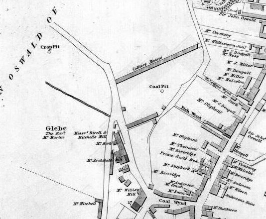
On an early 19th century map section, a Crop Pit is shown
on land which would now be just west of Dunnikier Road, north
of Coal Wynd. Another coal pit (name not indicated) is shown
a few hundred yards to the south-east, close to the top of
Fish Wynd. Few details on these early coal-works, other than
location, have been uncovered but it is quite likely that
they worked small areas of Rough Coal as the St. Clair
Coal, and the upper leaf of the Cardenden Smithy Coal.
It was in this area, to the west of the harbour, that a
number of pits, including the Bye Pit, operated in the early
decades of the 19th century.
 |
Click on Map to Zoom In
| Plans of Abandoned Seams for Bye Pit and Kirkcaldy | Pits or Mines designated in Plans |
|---|---|
| COAL; Three Feet; Four Feet; Five Feet (1818) | KIRKCALDY: Bye; Engine; Gin; Stair |
| COAL; Seam unnamed (1820) |
KIRKCALDY
Plan Custodian: Stella Coal Company, Blaydon, Durham |
| See also Crop Pit entry |
|---|
Can do with help on this pit.
