Owners: Whittaker & Street
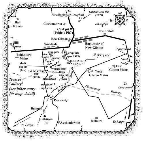
Baldastard farm, in the parish of Largo, is approximately
three miles to the north of Largo and just over ¼ mile
south of the shafts around Appleton farm which comprised the
late 19th century Woodside Colliery.
Nearby, several small coal pits (probably
'bell-pits') in the surrounding lands, e.g. at
Baldastard Mains, were possibly worked from the beginning of
the nineteenth century, or earlier, being known locally as
either the Baldastard or Woodside colliery.
An entry in the "Monthly Advertiser for West Fife"
for February, 1839, intimating the Let of Baldastard Farm, indicated
that 'Coal is at present working on the lands, and extensive
Lime-works on the Property adjoining.'
The Baldastard Pit, south of Appleton and approx 200 yds.
north of Baldastard farm, is known to have worked three seams
of coal in the late 1890s and was probably only sunk in 1896
following the boring in the area north of the farm which took
place in that same year. This Baldastard Pit, owned by
Whittaker & Street, is said to have been "drowned
out 1899".
One recently researched source (September, 2002) suggests
that a 'trial' pit may have been sunk, around 1897, a
few hundred yards to the east of the Baldastard Pit to a good
seam with high quality fireclay at a depth of 16 fathoms.
Reports that a small brickwork may have been set up in the
area, as a result of the fireclay discovery, are being
investigated. It is unlikely that most pits in the Appleton
Basin worked much beyond 1900 but one unverified source
suggests that fireclay extraction may have gone on for a few
years into the next century.
 |
 |
| Pic-1 |
|---|
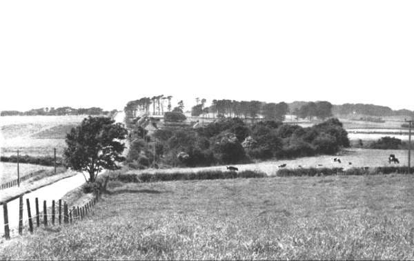
| Pic-1 | At
Woodside, near Largo. "It is difficult to believe
that these idyllic acres were once festooned with pit
buildings."
(Photograph and quotation from "THIS IS MY KINGDOM" by Charles Brister) |
|---|
Baldastard Colliery
| Source Date of Information (Owner) |
|---|
| 1899 (Whittaker & Street) |
| ca 1911 ? (Baldastard Coal & Fireclay Co.) |
-------------------------------------------------------------------
| The close proximity of many farms or steadings from
which different pits, or collieries, took their name can
often lead to difficulties. The Baldastard or Woodside or
Teasses pits fall into this category and, in the absence
of full records, it is often difficult to provide exact
categorisation, especially when official records list the
same working under different names. We welcome any
information/comments to help us in our task.
M. Martin & Webmasters. |
-------------------------------------------------------------------
Extract: Statistical Account
of Fife
Parish of Largo - 1791
" ... coal may be wrought to advantage. On the estate of Lundin, the coal has been cropped; but by erecting an engine near the sea, a deep seam, which stretches over upon the estate of Largo, would be opened. This would amply supply the neighbourhood, and afford besides a considerable exportation. ..."
-------------------------------------------------------------------
Extract: Statistical Account
of Fife
Parish of Largo - 1845
" ... Many years ago, coal was wrought in large quantities, especially near the coast. At present, there are three seams wrought, but none of them are of the first quality. To the north of New Gilston a singular mass of rum coal is found, under the mass of overlying trap on the south. It is an inflammable bituminous shale, and is extensively used for lime-burning. It is known to be 80 feet thick, and is wrought in an open quarry. ..."
-------------------------------------------------------------------
Information on coals worked at, or near, Baldastard
(based on a report/plan from 1900)
In 1879, the day level mouth to the south of Baldastard farm was described as "venting a good deal of water which would indicate considerable workings were being drained." (This probably relates more to the workings of the Woodside Colliery which lay to the north of Baldastard.)
Around Hall Teasses, it was found that coals were very
foul and blind due to deprivation of bitumen.
Further evidence of the disasterous effects of igneous
intrusions on the coals was revealed by a series of borings
sunk around 1896/97 in the low ground to the east. Three
trials were made in a line on the alluvial flat to the east
of Hall Teasses. Each of them stopped in "hard
whinstone", which was reached at depths varying from 7
to 24 fathoms. One of them passed through three coal seams,
all of which were blind and thin, ranging from 10 to 15
inches in thickness.
About 450 yds. further south, on the opposite side of the
moss, a diamond drill, which was put down to a depth of just
over 105 fathoms, pierced a "whinstone" sheet 200
ft. thick, at a depth of 46 fathoms, and ended off in another
at the bottom. Three thin coal seams were encountered above
the sill passed through, and each of them was found to be
blind. The diamond bore also passed through 2 ft. 4 in. of
limestone at 88 fathoms, and another seam 10 ft. 7 in. thick
at 98 fathoms. These were obviously the lower limestones, but
the numerous and valuable coal seams which usually overlay
them were found to absent in this case.
In spite of these serious obstacles to successful mining,
coal has been searched for and worked at various parts of the
field, especially towards the south between New Gilston and
Baldastard, at a greater distance from the invasive
"whinstone". In this tract, some of the series of
the lower coals were met with.
The Splint Coal of this part of the field, 3 ft. thick,
cropped out between Brankston, just south-west of Teasses
Colliery, and Baldastard, first with a north-westerly dip,
the outcrop then swinging towards the east, so that the seam
was 36 fathoms deep at Baldastard.
In this area sometimes referred to as the Appleton Basin, the Largoward Black Coal was proved by the Baldastard Borehole (1896) to be split, as at Largoward, into widely separated leaves, but the total amount of coal (around 3 ft. 7 in.) was less in this bore than was usual at Largoward; the top leaf (1 ft. 7 in.) being the thickest.
The Largoward Splint Coal was also proved in several bores to be between 2-3 ft. thick in the Appleton Basin.
The seam worked as the 'Marl Coal' in a small area
of Lathallan, was provisionally equated with the Aplleton
Splint Coal which was said to be 4 ft. in its small outcrop
in the centre of the Appleton Basin.
However, since apparently none of the borehole sections
through the supposed Marl Coal or Appleton Splint were
examined by a geologist, positive identification of these
seams as the Marl Coal was not possible.
In the Lathallan and Appleton areas, there was a coal, 15 in. to 27 in. thick, which lay some 50-59 ft. below the supposed Marl Coal. It was known at Lathallan as the Little Coal and worked at Appleton as the Ell Coal.
-------------------------------------------------------------------
| Plan of Abandoned Seams for Appleton | Pits or Mines designated in Plan |
|---|---|
| COAL; Appleton; Ell; Splint | Appleton |
| Plans of Abandoned Seams for Baldastard | Pits or Mines designated in Plans |
|---|---|
| COAL; Seam unnamed | Pits SW of Baldastard Mains |
| COAL; Splint; Bulfo | Pits from Unthank to Baldastard |
| Plans of Abandoned Seams for Baldastard or Woodside | Pits or Mines designated in Plans |
|---|---|
| COAL; Ell (May, 1899) | Woodside or Baldastard |
| COAL; Main; Splint | Woodside |
-------------------------------------------------------------------
"The Scotsman"
30 March, 1839
FARM IN FIFE TO BE LET.
THE FARM of BALDASTARD, in the parish of Largo, and county of Fife. ... Every encouragement will be given to a tenant of enterprise and capital, and the farm from its extent and resources (there being abundance of both lime and coal on the lands,) is deserving of the attention of such. ...
-------------------------------------------------------------------
Can you help?
Did that small brickwork operate in the area at the turn
of the century using the local fireclay?
| See also Woodside Colliery in East Fife Index |
