Owner: Hon. Lady Mary Lindsay Crawford
(1829)
(Crawford Priory, nr Springfield)
later possibly Paton and Graham, lessees (1842)
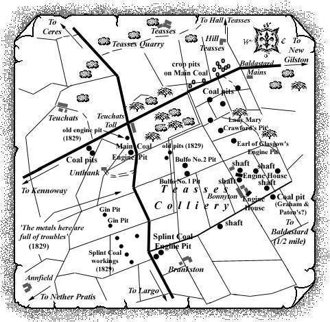
The two old coal pits to the east of the farm at Brankston (also Branxton) operated in the early part of the nineteenth century on Teasses Common. One of these pits is known to have been the Splint Coal Engine Pit and the other may have been known locally as the 'Gin Pit'. The Splint Coal Engine Pit is identified from a plan (see below) of 1829 in an area clearly marked with dykes or troubles. A plan label near the pit which was on the diphead level reads 'Forehead of Level 6 Fath into Dyke'.
 |
| Plan of Abandoned Seams for Branxton (Brankston) | Pits or Mines designated in Plan |
|---|---|
| COAL; Splint | Engine |
It has been our pleasure to view a copy of a plan of
early Teasses coal-works dating from 1829. It was kindly sent
by Ian Terris, Glenrothes, to whom we are very grateful. We
have described for your interest some of the detail we can
make out on the copy of the plan.
M. Martin & Webmasters
--- of ---
TEASSES COMMON
----- with the BARONIES of -----
BALMAIN and PITCRUIVIE
-------- the MINERALS under which --------
-------- are the PROPERTY of --------
THE HON BLE LADY MARY L. CRAUFURD
----- of Craufurd & Kilbirnie -----
Surveyed under the direction of John Williamson, Esq., Mining Engineer
by James Horne
Oct. 1829
The Scottish Record Office plan copy measures approx 21
in. x 28 in. and is very dark (poor copy) at the top and
bottom.
The visible area covers Teuchats (NW plan corner) to New
Gilston, Appleton and Boghall (NE plan corner). To the north,
Hill Teasses is just visible (Teasses Estate: The Property of
Captain Stark).
Pitcruivie with its old castle (SW plan corner) and
Wormwell, on the slopes of Largo Law (SE plan corner) are
easy to make out.
The whole plan shows numbered fields* which relate to the various land proprietors of the surface but a table in the south-east corner of the plan clearly states that the minerals under the surface belong to Lady Mary L. Craufurd (Crawford). The plan covers the Baronies of Balmain (* 61 to 97) and Pitcruivie (* 98 to 115) and also Teasses Common (* 1 to 60).
The principal landowners for the lands of Teasses Common
are listed:
Teasses Estate - Captain Stark
Teuchats Estate - R. B. Dundas, Esq.
Baldastard Estate - Sir Robert Preston, Bart.
Guilston Estate - James Wylde, Esq.
New Guilston Estate - James Kidd, Esq.
Largo Estate - General Durham
Balcormo - Captain Ker
All of the named pits and crop pits shown on the plan are in fields numbered 1 - 60 i.e. on the Teasses Common. We cannot make out a single coal work on any of the other numbered fields. The scroll plans to be kept at each of the collieries had these numbered fields inserted in them.
The vast number of crop pits dotted on the plan in the grounds between Teuchats and Hill Teasses are too numerous to plot on the scale of map we have on the website. None of these pits is identified by either name or number on the plan and our present website map has the locations of a number of these crop pits on the Main Coal located on a later source.
What the plan has shown, which we did not know of already, are the following:
an old engine pit just to the south of Teuchats toll;
the two Gin pits to the south of Unthank;
the five pits working the Splint Coal to the south of these Gin pits;
one of the pits to the west of Brankston farm or steading is clearly labelled the Splint Coal Engine Pit.
Unfortunately, the only part of the plan which shows any detail of underground workings - to the east of Norries Law - is too faint on the plan to be of any real use. These are the underground workings of what we have established earlier as the pits known as Lady Mary Crawford’s Pit and the Earl of Glasgow’s Engine Pit. All the shafts around Baldastard, Appleton and Boghall are not present on this plan being sunk later on in the 19th century. Even for the early working at Wormwell, which we have on site, there is no old pit shown on this plan of 1829 so at least we know it was later than this date.
--------------------------------------------
Extract: Statistical Account
of Fife
Parish of Largo - 1791
" ... coal may be wrought to advantage. On the estate of Lundin, the coal has been cropped; but by erecting an engine near the sea, a deep seam, which stretches over upon the estate of Largo, would be opened. This would amply supply the neighbourhood, and afford besides a considerable exportation. ..."
--------------------------------------------
Extract: Statistical Account
of Fife
Parish of Largo - 1845
" ... Many years ago, coal was wrought in large quantities, especially near the coast. At present, there are three seams wrought, but none of them are of the first quality. To the north of New Gilston a singular mass of rum coal is found, under the mass of overlying trap on the south. It is an inflammable bituminous shale, and is extensively used for lime-burning. It is known to be 80 feet thick, and is wrought in an open quarry. ..."
--------------------------------------------
| Refer also to Teasses Colliery entry in East Fife Index. |
|---|
