Owners: not known
| Much of East Fife's rural landscape masks its
industrial past. Many quiet pastures in our lovely
Kingdom were once scenes of coalmining activity in the
eighteenth and early nineteenth centuries. Although
little now survives of these coalmining activities which
were on a very much smaller scale than modern pits, the
fresh ploughing of a field will often reveal some
evidence in the appearance of patches of dark pit waste
from former workings. Examination of aerial photographs
of these areas can reveal a landscape covered with small
indents and markings suggesting the sites of many unnamed
old shafts and shallow workings. Often a brief mention in
an old document is the only evidence that they once
existed. Nevertheless, they too deserve to be recognised
in our record of the coalmines and pits of Fife.
Early Statistical Records for the parish of Dunino reveal the extent of coal mining here in the 18th century, and perhaps even earlier. |
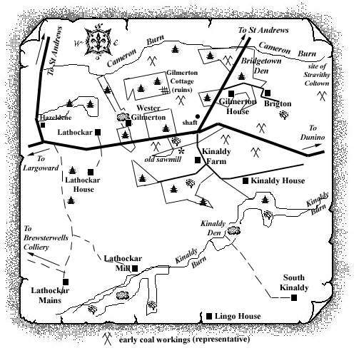 |
Extract from Statistical Account of Fife
Dunino Parish - 1795
"Coal seams, from the vast number of old pits in
various places of the parish, to have, some time ago, been a
very plentiful article here. There is still, it is said,
plenty of it in several estates of this district, but it is
uncertain when any of its proprietors will open these mines,
or rather, whether their future gains would compensate the
expenditure necessary for that purpose.
... The leading subject of complaint, with the inferior
classes of our parishioners, is the scarcity of coals, (the
only article of the parish fuel), even in the land of
coal. By the selfishness of individuals, the people here
seem to be, in a great measure, excluded from those
inestimable and necessary favours, so liberally poured around
them, by the benignity and wisdom of the Almighty. For,
notwithstanding the great quantity of coals formerly raised
in our immediate neighbourhood, the spirit of monopoly has
for many years past deprived us of this bounty of Providence;
and it is hard to say how long the same spirit may continue
to afflict the poor of this parish; the principal proprietor
of the coal-mines here having entered into an agreement with
the proprietor of an adjoining colliery, to keep his own
coal-works shut till those of the other shall be completely
exhausted; in return for which the other has bound himself,
and his heirs, & c. to pay him an annuity of £20
a-year!
Thus the poor of this parish, as well as the adjacent
country, are deprived of a blessing evidently intended for
them by Providence; and obliged to purchase fuel from a
considerable distance, at a higher price, and of a worse
quality."
Extract from Statistical Account of Fife
Dunino Parish - 1837
"The parish of Dunino is situated on the north-east part of the great coal basin of Scotland, supposed to be 90 miles long, and 33 miles broad. It is believed that a square mile of this space will answer the demand yearly. ... On every estate in the parish, are vestiges of coal-working at some former period; and very frequently at the surface, appears bituminous schistus or blaes, denoting the presence of this mineral. No coal is at present wrought in the parish, from a belief it would not pay the expense; and nothing is more difficult to calculate than the profits of coal-working."
Information of coals worked at, or near, Brigton, nr Dunino
(based on a 1900 report)
Although seams of coal were not infrequent in the
Carboniferous system of Fife below the Hurlet Limestone, they
were for the most part too thin and poor to be of use.
However, some of them became thick enough in the inland
district between Balcormo, near Carnbee, and Brigton near
Dunino, to have been once largely worked. It was revealed in
these old workings that the coal seams maintained a greater
regularity and persistence of outcrop than the coals that lay
above the Hurlet Limestone in this part of Fife but they did
not escape the dislocations and invasions by igneous rocks
which played havoc among the coal-bearing strata. Most of the
workings are of old date and were probably shallow, nothing
being known of the condition of the seams to the dip of the
pits.
A coal, three feet thick (possibly the Back Coal) cropped out
in the den to the east of Brigton, lying on white sandstone
(which was quarried here) and covered by black shale.
There were traces of the working of a lower seam in the
fields further east. [These may be the small 18th century
coal-works thought to be wrought by the residents of
Stravithy Coltown which was just under a mile to the east of
Bridgetown Den.]
A four feet thick coal came to the surface on the west side
of Brigton, and was worked by a mine entering from Brigton
Den. The workings were regular and the level-course ran in a
northerly direction nearly parallel to the ravine.
Other old pits in the fields to the west, mark shallow
sinkings in a four-feet seam of coal.
At Gilmerton, traces of the outcrops of coals and black
shales show that these strata had, in the west part of the
field, a southerly dip.
In 1892, a number of bores were put down on the lands of
Brigton and Gilmerton, but they did not lead to any hopeful
results. In one of them, situated 140 yds. to the east of the
southern end of Brigton Den, the Fore Coal was pierced at a
depth of 70 ft. It lay beneath its usual limestone roof which
was 2 ft. 11 in. thick, but the coal seam had a thickness of
only 2 ft. 9 in., with two partings of stone and fireclay,
amounting together to 2½ in.
... and based on a geological survey (1977) ...
Five bores put down around Gilmerton in 1892 all showed irregular alternations of strata with a few coals and limestones. One encountered old workings 6 fathoms below the surface. Exposures in Bridgetown Den and an old quarry approx 170 yds.south of Gilmerton House were almost all of sandstone with some shale and mudstone. A 'cherry coal' was formerly visible. The dip is to the west at 10o to 18o.
A coal seam 4 ft. thick is said to crop out on the east
side of the den, and to have been worked west of the den. A
seam of the same thickness was reported at a depth of about
14 fathoms in the shaft west of the south end of the den, but
the No. 4 bore put down only 130 yds. west of this shaft
encountered no seam thicker than 14 in.
Farther north-west, near the ruins of Gilmerton Cottage, a
coal overlain by black shale is said to crop out, dipping to
the south although the direction of this dip has been
questioned.
In a gully 550 yds. east of Gilmerton House, black shales are
exposed on the west side, with sandstone and sandy mudstone
on the east side. A coal 3 ft. thick is said to crop out in
the bottom, where there are traces of old workings.
[The 1977 report casts some doubt on the accurate
identification of the Back and Fore coals in the Gilmerton
area.]
