Owners: not known
The Auchmuty Pit, probably worked in the 18th century (into early 19th century?) and was located to the south of the River Leven, in the lands of Auchmuty, on the same side of the river as Lindsay's Mill, a likely fore-runner to the Rothes Paper Mill which developed on this site in the late 19th century.
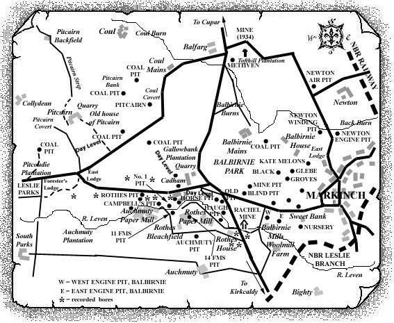
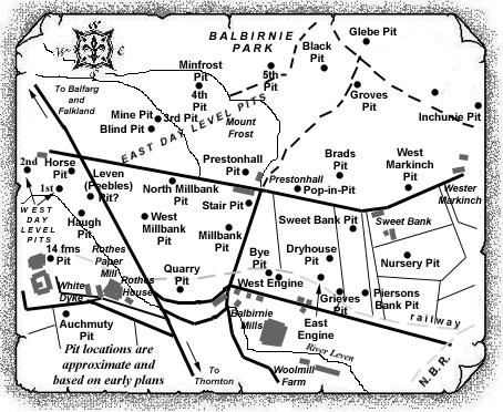
Other small pits (about which little is known) in the area just north-west of the Auchmuty Pit were the 11 Fms Pit and the 14 Fms Pit (see map).
There is even some evidence to suggest that, perhaps, other small coal-works may have existed close by Lindsay's Mill, and north of the '11' and '14' fathoms pits, as part of a system of 'sinks' along the old Rachel Mine which is thought to have run from the Balbirnie Engine pits, further east, to the engines in the underground workings of the small pits in the lands of Cadham.
 |
 |
An old sketch map of the Cadham and Auchmuty Coalfields
indicates the locations of four bores just a few hundred
yards to the east of the Auchmuty Pit close to land/property
owned by a 'Mr. Low'.
It is unlikely that detailed records of seams worked at this
individual pit exist but some information on this small
coalfield is available from an abandonment plan and from
geological memoirs of 1900 and 1934.
| Plan of Abandoned Seams for Auchmuty | Pits or Mines designated in Plan |
|---|---|
| COAL; Main (1820) |
Auchmuty and Cadham:
Bogie; Greiges [Plan Custodian: J & G. H. Geddes, Edinburgh] |
| See Balbirnie
Colliery entry (East Fife Index)
for fuller details of the old workings of this very important, early Fife coalfield, close to Auchmuty |
|---|
Information on the Cadham Coalfield
(based on a 1934 report)
The Cadham Coalfield lay immediately to the west of
Markinch. The greater part of it fell within what could still
be termed Central Fife but it extended for a short distance
across into East Fife. It was a small coalfield and, except
for an isolated strip in the vicinity of Caskieberran,
1¼ mile to the south-west of Auchmuty farm, which is
recorded as containing "two thick coals", it was
contained in an irregular synclinal fold which was bounded on
all sides but the north by rocks of the Lower Limestone
Group.
The "two thick coals" found at Caskieberran are
thought to have represented the Five Foot and the Dunfermline
Splint Coals. The sediments were invaded by an intrusive
dolerite exposed on the northern slopes of a low ridge, 300
to 600 yards E.S.E. of the farm of East Goatmilk, one mile to
the west of Caskieberran. No information on small pits
working these coals has yet been uncovered.
| See also Coalfield
Link
for a general section of the Cadham Coalfield |
|---|
On the north, it was cut off by the Coul fault which
crossed the district from Little Balgothrie in the west, to
Gateside in the east, bringing up Calciferous Sandstone and
Lower Limestone Group rocks, with their associated igneous
intrusions, against the coal-bearing strata. The latter were
contained in two shallow basins incompletely separated from
one another by a low anticlinal ridge which pitched gently to
the south from the Coul fault west of Gateside to Cadham.
On the eastern side of this fold, and running parallel to it,
was the elongated basin containing the Balbirnie workings; in
it, the rocks of the Limestone Coal Group extended southwards
and south-westwards for about a mile beyond Auchmuty. Along
the eastern side of the trough, the angles of dip were high,
but elsewhere the metals were usually gently inclined. Only
the lower part of the Limestone Coal Group was preserved and
this contained only a single coal of workable thickness,
known as the Main Coal. Numerous abandoned pits indicated the
extent to which the field was exploited and there can be no
doubt that it is practically exhausted.
Few faults of any consequence were known to disturb this
small coalfield. One, with an east-and-west trend and a
displacement to the south of perhaps 20 fathoms, passed about
midway between Cadham and Auchmuty. A second fault, diverging
from the last fault described in a W.N.W. direction at a
point near the eastern margin of the field, had a downthrow
to the north of about 15 fathoms. This fracture was
encountered in underground workings south-east of the Rothes
Paper Mills and appeared at the surface in the left bank of
the River Leven, a short way to the west of the Auchmuty
Paper Mills. There was evidence of faulting in a bore a
quarter of a mile south-west of Auchmuty, but nothing is
known as to the direction or size of the disturbance.
A fault crossing the western basin from near Balgeddie, past
Collydean, to the Coul fault north of Coul, had an estimated
downthrow to the south-east of about 50 fathoms. Its effect
was to restrict the outcrop of the Limestone Coal Group on
its northern side very considerably, and consequently, the
presence of the Main Coal in the northern part of the basin
is highly improbable.
There were grounds for believing that a small, though probably disturbed, area of the Main Coal may have existed in the southern part of the eastern basin, south of the east-west fault that passed between Cadham and Auchmuty, but direct evidence on this point was lacking.
-------------------------------------------------
"Fifeshire Journal"
5 October, 1837
MARKINCH - SERIOUS ACCIDENT
On Friday night, between ten and eleven o'clock, while the workmen were engaged in sinking a coal-pit in the neighbourhood of Rothes Bleachfield, a charge of gunpowder by some accidental cause, exploded, whereby one of the workmen was so shockingly mangled that immediate amputation of the leg was considered by the medical gentlemen inevitable. The other two workmen narrowly escaped with little injury. Various accounts are abroad in the public regarding the cause of the explosion. This is the third accident that has happened in the sinking of the pit - two from the effects of gunpowder, and one from the falling of a stone from the pit mouth, whereby several men have been injured.
-------------------------------------------------
Can do with help on these old pits
